【Redis应用】查看附近(五)
Redis应用学习·第五站~
本文已收录至专栏:Redis技术学习
查看附近的XXX在我们的实际应用中非常广泛,能支持该功能的技术有很多,而在我们的Redis中主要依靠GEO数据结构来实现该功能!
一.GEO用法引入
GEO,全称Geolocation,代表地理坐标。可以在其中存储地理坐标信息,帮助我们根据经纬度来检索数据。常见的命令有:
GEOADD:添加一个或多个地理空间信息,包含:经度(longitude)、纬度(latitude)、值(member)GEODIST:计算指定的两个点之间的距离并返回GEOHASH:将指定member的坐标转为hash字符串形式并返回GEOPOS:返回指定member的坐标GEORADIUS:指定圆心、半径,找到该圆内包含的所有member,并按照与圆心之间的距离排序后返回。(6.2以后已废弃)GEOSEARCH:在指定范围内搜索member,并按照与指定点之间的距离排序后返回。范围可以是圆形或矩形。(6.2以后新命令)GEOSEARCHSTORE:与GEOSEARCH功能一致,不过可以把结果存储到一个指定的key。(6.2以后新命令)
我们可以在redis服务器使用命令 help xxx 查看指令的具体用法~
- 使用示例:
# 1. 添加下面几条数据:
# 北京南站( 116.378248 39.865275 ) 北京站( 116.42803 39.903738 )
# 北京西站( 116.322287 39.893729 )
geoadd station 116.378248 39.865275 bjn 116.42803 39.903738 bj  116.322287 39.893729 bjx
# 1.计算北京西站到北京站的距离
geodist station bjx bj m
# 2.搜索天安门( 116.397904 39.909005 )附近10km内的所有火车站,并按照距离升序排序
georadius station 116.397904 39.909005 10 km asc
接下来我们结合附近商户实际场景来使用一番~
二.项目实战
(1) 案例说明
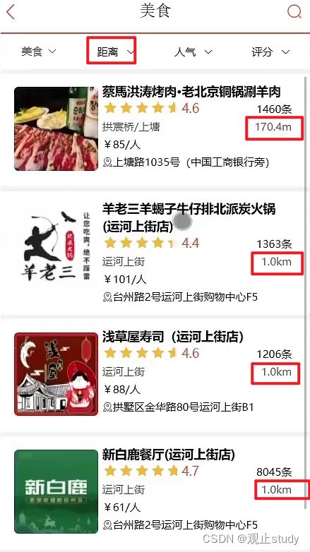
当我们点击美食之后,会出现一系列的商家,商家中可以按照多种排序方式,我们此时关注的是距离,这个地方就需要使用到我们的GEO,向后台传入当前app收集的地址(我们此处是写死的) ,以当前坐标作为圆心,同时绑定相同的店家类型type,以及分页信息,把这几个条件传入后台,后台查询出对应的数据再返回。
![]()
(2) 数据导入
要完成这个功能,我们首先要做的事情是将数据库表中的分类id:商户id:地理坐标信息导入到redis中去,我们可以按照商户类型做分组,类型相同的商户作为同一组,以typeId为key存入同一个GEO集合中即可

- 导入数据实现代码:
@Test
void loadShopData() {
    // 1.查询所有店铺信息
    List<Shop> list = shopService.list();
    // 2.把店铺分组,按照typeId分组,typeId一致的放到一个集合
    Map<Long, List<Shop>> map = list.stream().collect(Collectors.groupingBy(Shop::getTypeId));
    // 3.分批完成写入Redis
    for (Map.Entry<Long, List<Shop>> entry : map.entrySet()) {
        // 3.1.获取类型id
        Long typeId = entry.getKey();
        String key = "shop:geo:" + typeId;
        // 3.2.获取同类型的店铺的集合
        List<Shop> value = entry.getValue();
        List<RedisGeoCommands.GeoLocation<String>> locations = new ArrayList<>(value.size());
        // 3.3.写入redis GEOADD key 经度 纬度 member
        for (Shop shop : value) {
            // 设置店铺id,x,y坐标
            //  GEOADD key longitude latitude member [longitude latitude member ...]

            // 3.3.1 一条一条添加写入,效率较低
            // stringRedisTemplate.opsForGeo().add(key, new Point(shop.getX(), shop.getY()), shop.getId().toString());

            // 3.3.2 批量添加再一次性写入
            locations.add(new RedisGeoCommands.GeoLocation<>(
                    shop.getId().toString(),
                    new Point(shop.getX(), shop.getY())
            ));
        }
        stringRedisTemplate.opsForGeo().add(key, locations);
    }
}
(3) 功能实现
注意:SpringDataRedis的2.3.9版本并不支持Redis 6.2提供的GEOSEARCH命令,因此我们要提高版本或者使用6.2以后废弃的GEORADIUS命令,下面我们使用GEOSEARCH演示功能~
- 第一步:导入pom
<dependency>
    <groupId>org.springframework.bootgroupId>
    <artifactId>spring-boot-starter-data-redisartifactId>
    <exclusions>
        <exclusion>
            <artifactId>spring-data-redisartifactId>
            <groupId>org.springframework.datagroupId>
        exclusion>
        <exclusion>
            <artifactId>lettuce-coreartifactId>
            <groupId>io.lettucegroupId>
        exclusion>
    exclusions>
dependency>

<dependency>
    <groupId>org.springframework.datagroupId>
    <artifactId>spring-data-redisartifactId>
    <version>2.6.2version>
dependency>
<dependency>
    <groupId>io.lettucegroupId>
    <artifactId>lettuce-coreartifactId>
    <version>6.1.6.RELEASEversion>
dependency>
- 第二步:ShopController接收参数
// 接收 类别id,页码,以及当前坐标
@GetMapping("/of/type")
public Result queryShopByType(
        @RequestParam("typeId") Integer typeId,
        @RequestParam(value = "current", defaultValue = "1") Integer current,
        @RequestParam(value = "x", required = false) Double x,
        @RequestParam(value = "y", required = false) Double y
) {
   return shopService.queryShopByType(typeId, current, x, y);
}
- 第三步:ShopServiceImpl逻辑处理
@Override
    public Result queryShopByType(Integer typeId, Integer current, Double x, Double y) {
        // 1.判断是否需要根据坐标查询
        if (x == null || y == null) {
            // 不需要坐标查询,按数据库查询
            Page<Shop> page = query()
                    .eq("type_id", typeId)
                    .page(new Page<>(current, SystemConstants.DEFAULT_PAGE_SIZE));
            // 返回数据
            return Result.ok(page.getRecords());
        }

        // 2.计算分页参数
        int from = (current - 1) * SystemConstants.DEFAULT_PAGE_SIZE;
        int end = current * SystemConstants.DEFAULT_PAGE_SIZE;

        // 3.查询redis、按照距离排序、分页。结果:shopId、distance
        String key = "shop:geo:" + typeId;
        GeoResults<RedisGeoCommands.GeoLocation<String>> results = stringRedisTemplate.opsForGeo()
            // 原始命令: GEOSEARCH key BYLONLAT x y BYRADIUS 10 WITHDISTANCE
                .search(
                        key,
                        GeoReference.fromCoordinate(x, y),
                        new Distance(5000),
 RedisGeoCommands.GeoSearchCommandArgs.newGeoSearchArgs().includeDistance().limit(end)
                );
        // 4.解析出id
        if (results == null) {
            return Result.ok(Collections.emptyList());
        }
        List<GeoResult<RedisGeoCommands.GeoLocation<String>>> list = results.getContent();
        if (list.size() <= from) {
            // 没有下一页了,结束
            return Result.ok(Collections.emptyList());
        }
        // 4.1.由于geosearch始终是0~end,因此需要分页效果需要直接手动截取
        // 手动截取 from ~ end的部分
        List<Long> ids = new ArrayList<>(list.size());
        Map<String, Distance> distanceMap = new HashMap<>(list.size());
        list.stream().skip(from).forEach(result -> {
            // 4.2.获取店铺id
            String shopIdStr = result.getContent().getName();
            ids.add(Long.valueOf(shopIdStr));
            // 4.3.获取距离
            Distance distance = result.getDistance();
            distanceMap.put(shopIdStr, distance);
        });
        // 5.根据id查询Shop
        String idStr = StrUtil.join(",", ids);
        List<Shop> shops = query().in("id", ids).last("ORDER BY FIELD(id," + idStr + ")").list();
        for (Shop shop : shops) {
            shop.setDistance(distanceMap.get(shop.getId().toString()).getValue());
        }
        // 6.返回
        return Result.ok(shops);
    }


