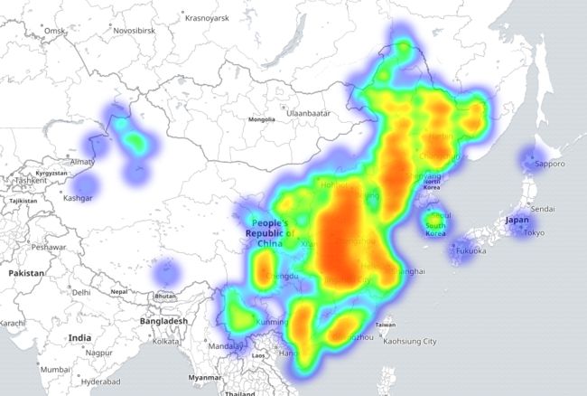
经常有这种需求,拥有用户的IP地址,想要在地图上显示用户的访问量。这个时候就需要用到经纬度...应为一般的地图插件都是基于经纬度的。
那么问题来了,如何把IP转换成经纬度?
百度API
最国产的方式,就是使用百度API了,百度提供了两种服务:
普通的IP服务:http://lbsyun.baidu.com/index.php?title=webapi/ip-api
https://api.map.baidu.com/location/ip?ak=请输入您的AK&coor=bd09ll返回值:
{
    address: "CN|吉林|长春|None|CERNET|1|None",
    content:
    {
        address: "吉林省长春市",
        address_detail:
        {
            city: "长春市",
            city_code: 53,
            district: "",
            province: "吉林省",
            street: "",
            street_number: ""
        },
        point:
        {
            x: "125.31364243",
            y: "43.89833761"
        }
    },
    status: 0
}
精准的服务:http://lbsyun.baidu.com/index.php?title=webapi/high-acc-ip
https://api.map.baidu.com/highacciploc/v1?qcip=220.181.38.113&qterm=pc&ak=请输入您的AK&coord=bd09ll返回值:
{
    content: {
        location: {
            lat: 40.047726,#纬度
            lng: 116.313304 #经度
        },
        locid: "8b1bf81d208bc2ce657fb6e6c270de66",#定位结果唯一ID
        radius: 30, #定位结果半径
        confidence: 1 #定位结果可信度
    },
    result: {
        error: 161,#定位结果状态码
        loc_time: "2016-08-23 15:14:12"#定位时间
    }
}
这个API也不是随便问的,首先就需要注册;每个时间段的访问量还有限...因此不适合做数据分析使用。因为数据分析往往是大批量的数据同时去进行经纬度的转换。
Logstash进行转换
Logstash本身提供了IP地址转换成经纬度的功能:
input{
    file{
        path => "D:\access.json"
        start_position => "beginning"
    }
}
filter{
    json{
        source => "message"
    }
    date{
        match => ["time","yyyy-MM-dd HH:mm:ss"]
        timezone => "Asia/Shanghai"
    }
    geoip {
                source => "ip"
                target => "geoip"
    }
}
output{
    stdout{
            codec => rubydebug
    }
}
MaxMind提供的GeoIp服务
这个公司提供了GeoIp的转换服务,当然如果想要精确的匹配也是收费的。
这里有一个体验的网址:https://www.maxmind.com/en/geoip-demo
东拼西凑山寨方案
这个山寨的方案灵感来源于Logstash,Logstash本身提供了IP转换经纬度的功能。原理就是它自己有一个IP数据库,可以通过它执行查询。其实这个数据库时老版的MaxMind提供的数据文件,凑合用吧!新的需要花钱呀!
废话不多说,在Java中想要使用这个数据文件需要下载相应的Jar包和dat文件:
- GeoIP jar包:geoip-api-1.3.1.jar
- Geo city dat文件:GeoLiteCity-2013-01-18.dat
把dat文件放在自己的本地目录,然后项目中导入geoip.jar即可:
import com.maxmind.geoip.Location;
import com.maxmind.geoip.LookupService;
import java.io.IOException;

public class TestMain {
    public static void main(String[] args) {
        try {
            LookupService cl = new LookupService("D:/lib/geoip/GeoLiteCity-2013-01-18.dat", LookupService.GEOIP_MEMORY_CACHE);
            Location l2 = cl.getLocation("144.0.9.29");
            System.out.println(
                    "countryCode: " + l2.countryCode +"\n"+
                    "countryName: " + l2.countryName +"\n"+
                    "region: " + l2.region +"\n"+
                    "city: " + l2.city +"\n"+
                    "latitude: " + l2.latitude +"\n"+
                    "longitude: " + l2.longitude);
        } catch (IOException e) {
            e.printStackTrace();
        }
    }
}
输出内容:
countryCode: CN
countryName: China
region: 25
city: Jinan
latitude: 36.668304
longitude: 116.99719
最后晒一个图,兴奋一下
参考
1 国外Geoip服务 MaxMind:https://www.maxmind.com/en/geoip-demo
2 国内Geoip服务 百度开放API: http://lbsyun.baidu.com/index.php?title=webapi/ip-api
