Openlayers6 Examples学习笔记(5)
文章目录
- View Animation(视图动画)
- GPX Data
- Map Graticule(地图网格)
- Earthquakes Heatmap(地震震级热力图)
- Hit Tolerance
- Icon Colors(自定义图片颜色)
- Vector Layer Hit Detection(矢量图层高亮)
- Icon Symbolizer(图标符号)
- Vector Image Layer(图层高亮)
- GeoJSON(加载GeoJSON数据)
- JSTS Integration(空间分析js库)
- KML(加载KML数据)
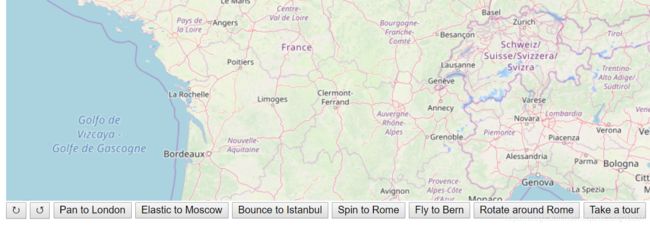
View Animation(视图动画)
import 'ol/ol.css';
import Map from 'ol/Map';
import View from 'ol/View';
import {easeIn, easeOut} from 'ol/easing';
import TileLayer from 'ol/layer/Tile';
import {fromLonLat} from 'ol/proj';
import OSM from 'ol/source/OSM';

var london = fromLonLat([-0.12755, 51.507222]);
var moscow = fromLonLat([37.6178, 55.7517]);
var istanbul = fromLonLat([28.9744, 41.0128]);
var rome = fromLonLat([12.5, 41.9]);
var bern = fromLonLat([7.4458, 46.95]);

var view = new View({
  center: istanbul,
  zoom: 6
});

var map = new Map({
  target: 'map',
  layers: [
    new TileLayer({
      preload: 4,
      source: new OSM()
    })
  ],
  view: view
});

// A bounce easing method (from https://github.com/DmitryBaranovskiy/raphael).
function bounce(t) {
  var s = 7.5625;
  var p = 2.75;
  var l;
  if (t < (1 / p)) {
    l = s * t * t;
  } else {
    if (t < (2 / p)) {
      t -= (1.5 / p);
      l = s * t * t + 0.75;
    } else {
      if (t < (2.5 / p)) {
        t -= (2.25 / p);
        l = s * t * t + 0.9375;
      } else {
        t -= (2.625 / p);
        l = s * t * t + 0.984375;
      }
    }
  }
  return l;
}

// An elastic easing method (from https://github.com/DmitryBaranovskiy/raphael).
function elastic(t) {
  return Math.pow(2, -10 * t) * Math.sin((t - 0.075) * (2 * Math.PI) / 0.3) + 1;
}

function onClick(id, callback) {
  document.getElementById(id).addEventListener('click', callback);
}

onClick('rotate-left', function() {
  view.animate({
    // 向左旋转90度
    rotation: view.getRotation() + Math.PI / 2
  });
});

onClick('rotate-right', function() {
  view.animate({
    // 向右旋转90度
    rotation: view.getRotation() - Math.PI / 2
  });
});

onClick('rotate-around-rome', function() {
  // Rotation animation takes the shortest arc, so animate in two parts
  var rotation = view.getRotation();
  // 两段动画
  view.animate({
    rotation: rotation + Math.PI,
    anchor: rome,
    // 开始缓慢,逐渐加快速度
    easing: easeIn
  }, {
    rotation: rotation + 2 * Math.PI,
    anchor: rome,
    // 开始迅速,逐渐减慢速度
    easing: easeOut
  });
});

onClick('pan-to-london', function() {
  view.animate({
    center: london,
    duration: 2000
  });
});

onClick('elastic-to-moscow', function() {
  view.animate({
    center: moscow,
    duration: 2000,
    easing: elastic
  });
});

onClick('bounce-to-istanbul', function() {
  view.animate({
    center: istanbul,
    duration: 2000,
    easing: bounce
  });
});

onClick('spin-to-rome', function() {
  // Rotation animation takes the shortest arc, so animate in two parts
  var center = view.getCenter();
  view.animate({
    center: [
      center[0] + (rome[0] - center[0]) / 2,
      center[1] + (rome[1] - center[1]) / 2
    ],
    rotation: Math.PI,
    easing: easeIn
  }, {
    center: rome,
    rotation: 2 * Math.PI,
    easing: easeOut
  });
});

function flyTo(location, done) {
  var duration = 2000;
  var zoom = view.getZoom();
  var parts = 2;
  var called = false;
  function callback(complete) {
    --parts;
    if (called) {
      return;
    }
    if (parts === 0 || !complete) {
      called = true;
      done(complete);
    }
  }
  view.animate({
    center: location,
    duration: duration
  }, callback);
  view.animate({
    zoom: zoom - 1,
    duration: duration / 2
  }, {
    zoom: zoom,
    duration: duration / 2
  }, callback);
}

onClick('fly-to-bern', function() {
  flyTo(bern, function() {});
});

function tour() {
  var locations = [london, bern, rome, moscow, istanbul];
  var index = -1;
  function next(more) {
    if (more) {
      ++index;
      if (index < locations.length) {
        var delay = index === 0 ? 0 : 750;
        setTimeout(function() {
          flyTo(locations[index], next);
        }, delay);
      } else {
        alert('Tour complete');
      }
    } else {
      alert('Tour cancelled');
    }
  }
  next(true);
}

onClick('tour', tour);
GPX Data
Map Graticule(地图网格)
Earthquakes Heatmap(地震震级热力图)
Hit Tolerance

默认情况下,map.forEachFeatureAtPixel()函数仅考虑直接位于所提供像素下方的要素。这会使与触摸设备上的功能进行交互变得困难。要考虑与提供的像素一定距离内的要素,请使用hitTolerance属性。例如,map.forEachFeatureAtPixel(pixel,callback,{hitTolerance:3})将使用位于提供的像素3个像素之内的所有要素来调用回调。
案例链接
Icon Colors(自定义图片颜色)

加载,空白的图片,通过setStyle方法,重新设置图片的颜色。


import 'ol/ol.css';
import Feature from 'ol/Feature';
import Map from 'ol/Map';
import View from 'ol/View';
import Point from 'ol/geom/Point';
import {Tile as TileLayer, Vector as VectorLayer} from 'ol/layer';
import {fromLonLat} from 'ol/proj';
import TileJSON from 'ol/source/TileJSON';
import VectorSource from 'ol/source/Vector';
import {Icon, Style} from 'ol/style';


var rome = new Feature({
  geometry: new Point(fromLonLat([12.5, 41.9]))
});

var london = new Feature({
  geometry: new Point(fromLonLat([-0.12755, 51.507222]))
});

var madrid = new Feature({
  geometry: new Point(fromLonLat([-3.683333, 40.4]))
});

rome.setStyle(new Style({
  image: new Icon({
    color: '#8959A8',
    crossOrigin: 'anonymous',
    src: 'data/square.svg'
  })
}));

london.setStyle(new Style({
  image: new Icon({
    color: '#4271AE',
    crossOrigin: 'anonymous',
    src: 'data/dot.png'
  })
}));

madrid.setStyle(new Style({
  image: new Icon({
    color: [113, 140, 0],
    crossOrigin: 'anonymous',
    src: 'data/dot.png'
  })
}));


var vectorSource = new VectorSource({
  features: [rome, london, madrid]
});

var vectorLayer = new VectorLayer({
  source: vectorSource
});

var rasterLayer = new TileLayer({
  source: new TileJSON({
    url: 'https://a.tiles.mapbox.com/v3/aj.1x1-degrees.json',
    crossOrigin: ''
  })
});

var map = new Map({
  layers: [rasterLayer, vectorLayer],
  target: document.getElementById('map'),
  view: new View({
    center: fromLonLat([2.896372, 44.60240]),
    zoom: 3
  })
});
Vector Layer Hit Detection(矢量图层高亮)
Icon Symbolizer(图标符号)
- 图标要素:iconFeature
- display popup on click
- change mouse cursor when over marker
案例链接
Vector Image Layer(图层高亮)
GeoJSON(加载GeoJSON数据)
JSTS Integration(空间分析js库)

JSTS是ECMAScript的空间谓词库,用于处理符合Open Geospatial Consortium发布的SQL简单要素规范的几何图形。JSTS也是完善的Java库JTS的移植。
该项目的主要目标是为Web制图应用程序提供一个完整的库,用于处理和分析简单的几何图形,但是JSTS也可以用作独立的几何图形库。
JSTS是通过将原始JTS Java源通过AST自动转换为保留JTS API的 AST转换而制成的,但与I / O相关的类除外,该类有选择地并手动移植以支持WKT,GeoJSON和OpenLayers 3+。
案例链接
JSTS与Openlayers使用链接
